
File:NWFP FATA.svg

Size of this PNG preview of this SVG file: 558 × 600 pixels. Ither resolutions: 223 × 240 pixels | 446 × 480 pixels | 714 × 768 pixels | 953 × 1,024 pixels | 1,905 × 2,048 pixels | 1,000 × 1,075 pixels.
Oreeginal file (SVG file, nominallie 1,000 × 1,075 pixels, file size: 171 KB)
Ootline
| Descreeption |
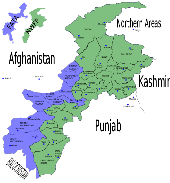
English: Map showing the districts of the Federally Administered Tribal Areas (FATA) and the North-West Frontier Province (NWFP) of Pakistan. |
| Date | |
| Soorce | Self made using Inkscape - Based on maps from http://www.nwfp.gov.pk |
| Author | Pahari Sahib |
| Other versions | Derivative works of this file: Pakistan NWFP FATA areas with localisation map.svg |
Licensin
I, the copyright holder of this work, hereby publish it under the following licenses:

|
Permission is grantit tae copy, distribute an/or modify this document unner the terms o the GNU Free Documentation License, Version 1.2 or ony later version published bi the Free Software Foundation; wi no Invariant Sections, no Front-Cover Texts, an no Back-Cover Texts. A copy o the license is includit in the section enteetled GNU Free Documentation License. |
| This file is licensed unner the Creative Commons Attribution-Share Alike 3.0 Unported license. | ||
| ||
| This licensing tag was added to this file as part of the GFDL licensing update. |
This file is licensed under the Creative Commons Attribution-Share Alike 2.5 Generic, 2.0 Generic and 1.0 Generic license.
- Ye are free:
- tae share – tae copy, distribute an transmit the wirk
- tae remix – tae adapt the wirk
- Unner the follaein condeetions:
- attribution – Ye must attribute the wirk in the manner specified bi the author or licensor (but nae in ony way that suggests that thay endorse ye or yer uise o the wirk).
- share alik – If ye alter, transform, or big upon this wirk, ye mey distribute the resultin wirk anly unner the same or seemilar license tae this ane.
Ye mey select the license o yer choice.
File history
Clap oan ae date/time fer tae see the file aes it kithed at that time.
| Date/Time | Thummnail | Dimensions | Uiser | Comment | |
|---|---|---|---|---|---|
| current | 11:04, 11 August 2015 | | 1,000 × 1,075 (171 KB) | Colajmal | issue with format |
| 11:03, 11 August 2015 |  | 1,000 × 1,120 (66 KB) | Colajmal | Map of KPK & FATA with ethnic breakdown | |
| 21:31, 6 Juin 2007 |  | 1,000 × 1,075 (171 KB) | Pahari Sahib | {{Information |Description=Map showing the districts of the Federally Administered Tribal Areas (FATA) FATA and the North-West Frontier Province (NWFP) of Pakistan. |Source= Self made using Inkscapte - Based on maps from http://www.nwfp.gov.pk |Date=0 |
Eimage airtins
The follaein pages airts tae this image:
Global file uisage
The follaein ither wikis uise this file:
- Uisage on ar.wikipedia.org
- Uisage on azb.wikipedia.org
- Uisage on be-tarask.wikipedia.org
- Uisage on be.wikipedia.org
- Uisage on ca.wikipedia.org
- Uisage on cy.wikipedia.org
- Uisage on da.wikipedia.org
- Uisage on en.wikipedia.org
- Military history of the North-West Frontier
- Hazara District
- Insurgency in Khyber Pakhtunkhwa
- User:AlexNebraska/Images of Pakistan
- 2008 Orakzai bombing
- 2009 Pakistan Army Mil Mi-17 crash
- Operation Sirat-e-Mustaqeem
- Babur's First Indian Expedition
- Qabailistan
- Twenty-fifth Amendment to the Constitution of Pakistan
- User:Falcaorib/Afghanistan
- Uisage on en.wikinews.org
- Uisage on eo.wikipedia.org
- Uisage on es.wikipedia.org
- Uisage on fa.wikipedia.org
- Uisage on fi.wikipedia.org
- Uisage on fr.wikipedia.org
- Uisage on hi.wikipedia.org
- Uisage on hu.wikipedia.org
- Uisage on hy.wikipedia.org
- Uisage on id.wikipedia.org
- Uisage on it.wikipedia.org
- Uisage on ja.wikipedia.org
- Uisage on ko.wikipedia.org
- Uisage on ms.wikipedia.org
- Uisage on new.wikipedia.org
- Uisage on nl.wikipedia.org
- Uisage on no.wikipedia.org
- Uisage on pa.wikipedia.org
- Uisage on pl.wikipedia.org
View mair global usage o this file.